
In 2025, the Town created the Bowerbank Road Neighbourhood Bikeway to improve safety and connectivity for people walking and cycling in Sidney, particularly youth travelling to nearby schools and parks.
The project was identified as a priority action in Sidney’s first Active Transportation Plan, which was developed through public engagement in 2022 and 2023. Rather than installing bike lanes, which would have required the removal of on-street parking, the Town implemented a neighbourhood bikeway design that uses traffic calming measures and traffic diversions to reduce cut-through traffic on Bowerbank Road and Siddall Road while maintaining vehicle access.
Following implementation, the Town monitored traffic conditions and gathered community feedback. Residents raised concerns about traffic redistribution and the impacts of the traffic diversions on surrounding streets. In response, the Town is changing portions of the bikeway, specifically the removal of the traffic diversion at Piercy Avenue. Additional public engagement is being planned to help inform future decisions regarding the bikeway.
The information below outlines the original project, its implementation, and subsequent project updates.
Project Updates:
- October 2026 – The Bowerbank Road traffic diversion at Piercy Avenue is now being removed. In response to community concerns about traffic impacts and reports of vehicles bypassing the traffic diversion, Council directed (on September 28) that southbound access on Bowerbank Road at Piercy Avenue be reopened to all traffic. Council also directed staff to develop a community engagement strategy for the Bowerbank Road Neighbourhood Bikeway and bring it forward for Council’s consideration before the end of 2026. The engagement process will help inform future decisions regarding the bikeway, including the remaining traffic diversion at Siddall Road and Mills Road. Council also requested that staff bring forward options for alternative traffic calming measures on Bowerbank Road and Siddall Road.
- September 2026 – Council received a report on the Bowerbank Road Neighbourhood Bikeway that found the project has reduced traffic volumes and vehicle speeds on Bowerbank Road and Siddall Road, meeting recognized All Ages and Abilities cycling standards. The report also included findings on how vehicle traffic has been redistributed to Resthaven Drive and neighbourhood connector roads.
In response to community concerns regarding traffic impacts and the bikeway design, Council directed staff to present a preliminary report at the September 21, 2026 Committee of the Whole meeting outlining potential alternatives, project costs, and provincial grant funding implications associated with modifying or removing bikeway elements, including the traffic diversions at Calvin Avenue and Siddall Road. Council will also consider a proposed 40 km/h speed limit on a section of Resthaven Drive at a future Committee of the Whole meeting.
- May 27, 2026 – Upgrades to the Resthaven and Bowerbank intersection are now complete, featuring improved flashing beacons that can now be activated by people riding bicycles. New cross-rides with “elephant’s feet” markings allow cyclists to cross without dismounting, with short sections of bike lane providing some refuge space as riders begin/complete their crossing. With this work done, all construction on the Bowerbank Neighbourhood Bikeway is now complete.
- March 3, 2026 – To complete the Neighbourhood Bikeway project, construction work at the intersection of Resthaven Drive and Bowerbank Road will be carried out throughout March. These upgrades will include:
- Enhancing the existing pedestrian flashing beacons
- Adding dedicated, beacon‑activated crossings for cyclists
- Building more accessible sidewalks with improved connectivity for pedestrians
Motor vehicle access will remain unaffected, however, drivers may experience brief delays and alternating traffic while roadwork is underway.
- September 26, 2025 – The Calvin Avenue multi-use path is now open for pedestrians and cyclists. Please watch for uneven surfaces alongside the pathway until final grading is complete. Crews will continue working through the fall to install lighting, plant trees, and finish the corridor with topsoil and grass seed.
- September 26, 2025 – The on-street Neighbourhood Bikeway is now partially complete between Amherst Avenue and Sidney Elementary School. Drivers may continue to carefully share the street except where signage indicates otherwise. Once the Calvin and Amelia intersections are resurfaced in early October, the Neighborhood Bikeway will be complete up to Melville Drive. In the meantime, cyclists are welcome to continue riding the entire Bowerbank corridor with caution for changing traffic conditions and ongoing work.
- August 27, 2025 -Traffic diversions are now in place, limiting turn directions at Mills Rd and Siddall Rd, and restricting southbound travel between Piercy and Calvin to buses and bicycles only. Crosswalk improvements are under construction at the corner of Calvin Ave and Bowerbank Rd. There is a temporary “no right” sign while roadwork is being done, however, once complete, this intersection will reopen so drivers on Calvin Ave can turn in either direction, as before.
- July 8, 2025 – Construction on Siddall Road will commence the week of July 14. During construction, the north end of the street will be fully closed to vehicle traffic, later reopening to right-out access only. Local traffic will still be able to access Siddall Road via Henry Avenue to the south.
- May 29, 2025 – Construction on the Calvin Ave path will commence the week of June 2 and continue for approximately eight weeks. During this time the pathway and surrounding land will be closed to public access. The Lochside trail will remain open, and can be accessed via either Amelia Ave or the newly-refurbished Gabriola Place pathway.
- May 29, 2025 – Traffic pattern changes and construction on Bowerbank and Siddall will begin in early July. Speed humps will also be added on Melville Drive over the summer, in coordination with other paving work.
Design:
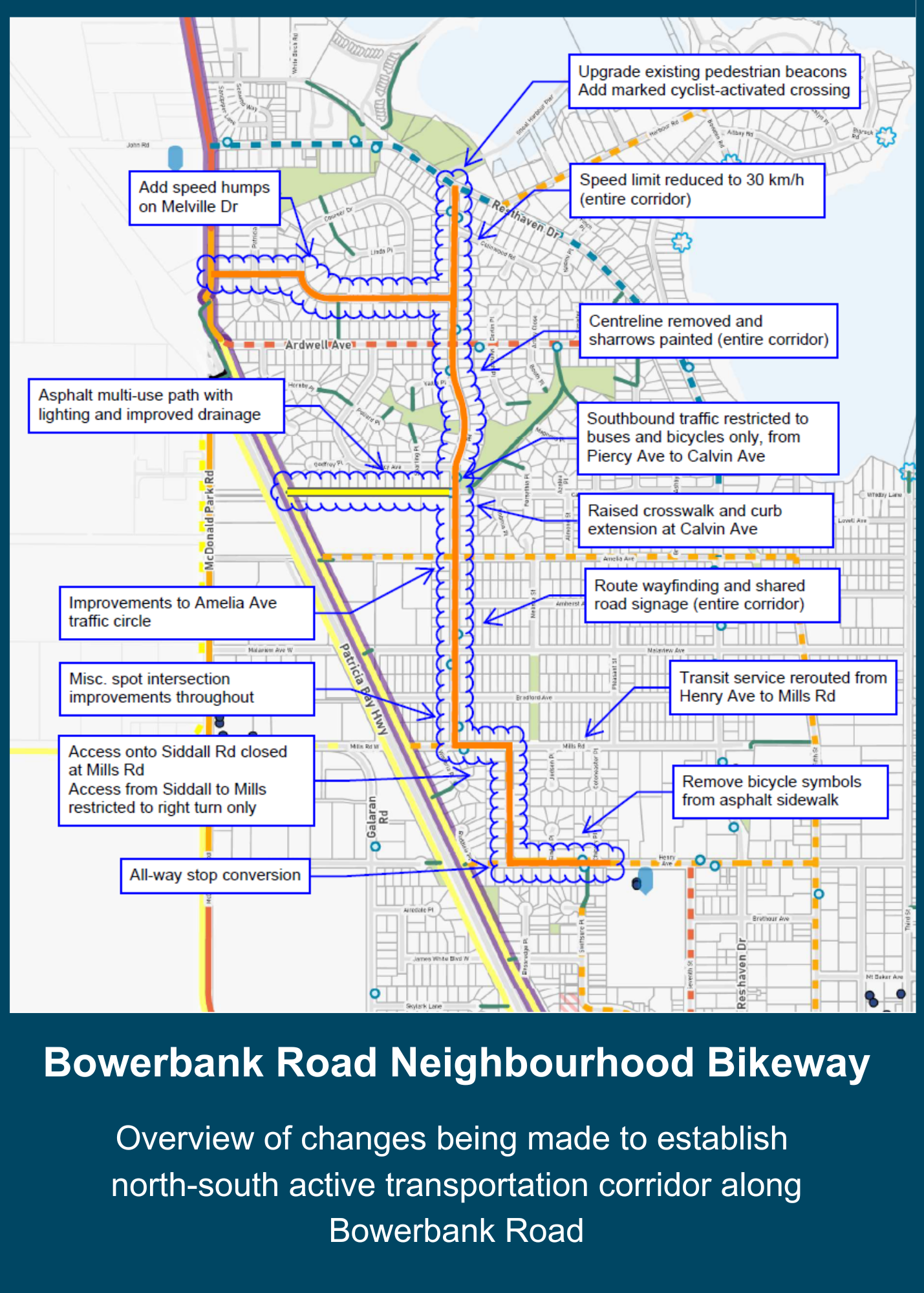
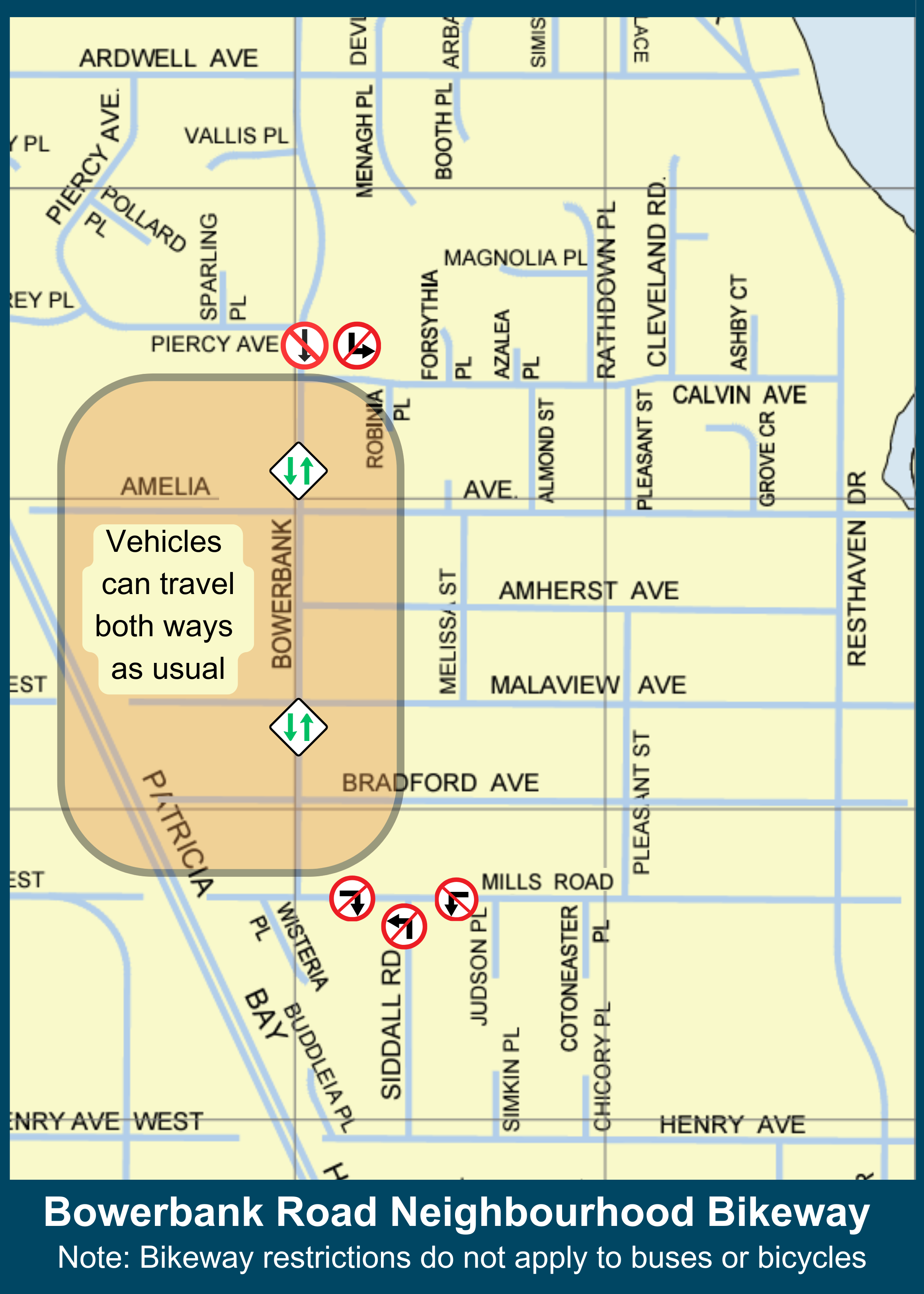
Below is a map detailing a number of changes that will be made to improve safety for cyclists and pedestrians and create Bowerbank Road Neighbourhood Bikeway. The most prominent change will be two traffic diversions, outlined in the second map, that will lessen traffic on Bowerbank Road and Siddall Road. Buses and cyclists will not be affected by these diversions.
(Removal underway)
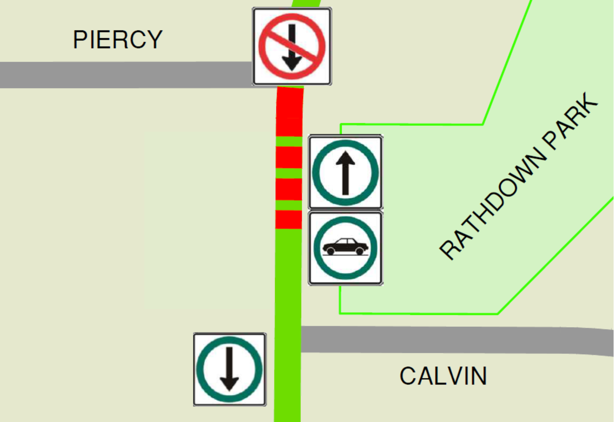
Traffic Diversion near Ardwell Avenue and Piercy Avenue
Vehicles travelling northward can still drive the full length of Bowerbank Road from Mills Road to Resthaven Drive, however, vehicles travelling southward cannot drive the full length of Bowerbank Road because of a diversion at Piercy Avenue. Instead, vehicles need to take Ardwell Avenue to Resthaven Drive to complete their journey south. This diversion reduces traffic on Bowerbank Road and makes it safer for cyclists to share the road with vehicles. Traffic flows freely in both directions on both sides of the diversion.
Traffic Diversion at Siddall Road and Mills Road Intersection
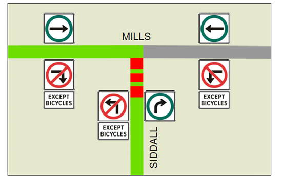
Vehicles heading north on Siddall Road must turn right onto Mills Road, and can no longer turn left toward Bowerbank Road. Mills Road traffic travels east-west, but vehicles can no longer turn south onto Siddall Road. This diversion reduces traffic on both Bowerbank Road and Siddall Road, making it safer for cyclists to share the road with vehicles, especially students and families heading to and from Sidney Elementary School.
Additional Improvements:
Two additional projects further support walking and cycling in the area.
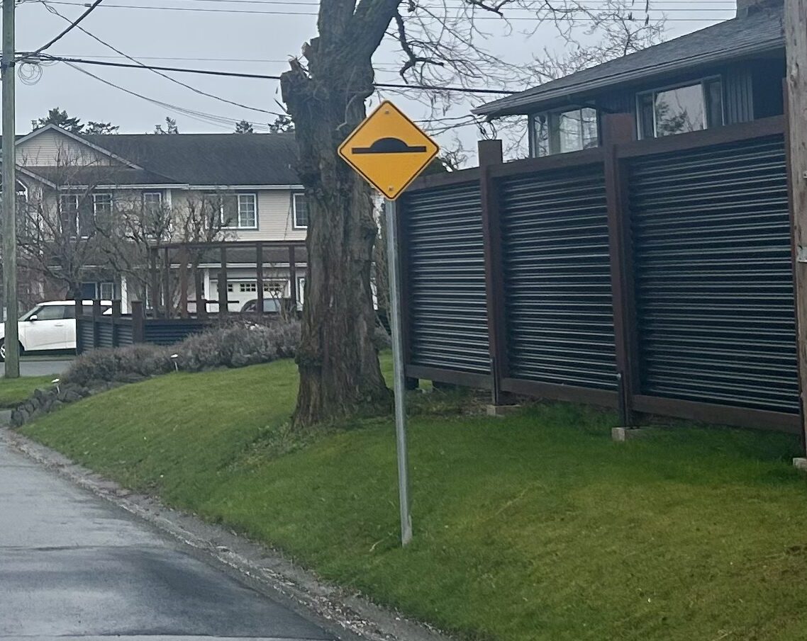
Speed Humps on Melville Drive
Since Melville Drive is an important connector to North Saanich Middle School but does not have sidewalks or bike lanes, speed humps have been installed to slow the speed of vehicles on the road.
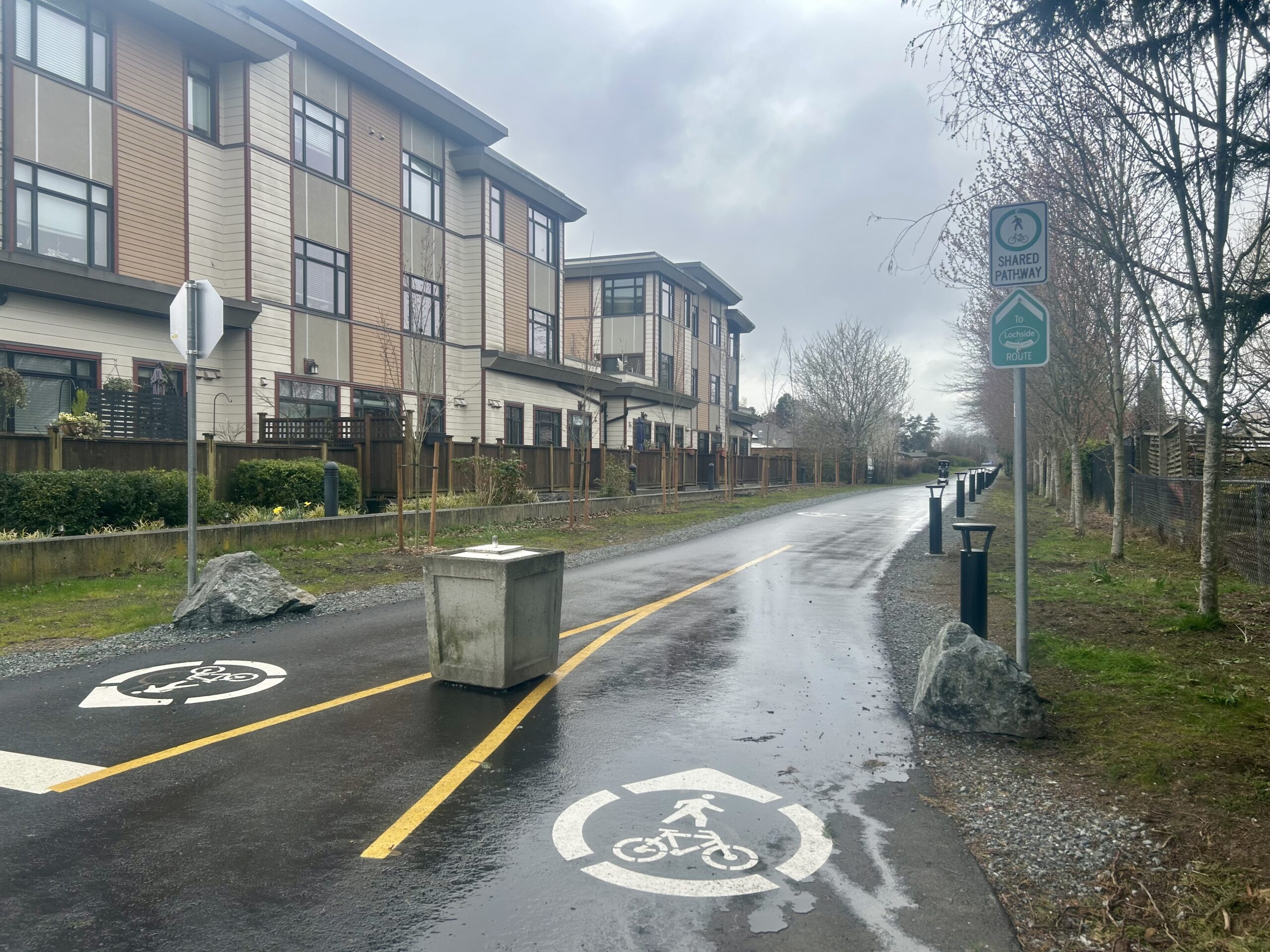
Paving of Pathway at Calvin Avenue
The wood-chip path connecting the Lochside Regional Trail to Calvin Avenue was paved and lit to make it accessible to mobility devices and more suitable for cyclists.
Funding:
A BC Active Transportation Grant will cover up to 70% of project costs with a contribution of $500,000. The majority of these costs are related to paving and adding lighting to the wood-chip path connecting the Lochside Regional Trail to Calvin Avenue to make it accessible to mobility devices and more suitable for cyclists.
Resources:
Staff Report: Bowerbank Bikeway Post-Implementation Traffic Monitoring Review (September 2026)
Traffic Count Map (September 2026)
Staff Report: Preliminary Design of Bowerbank Bike Boulevard (October 2023)
Active Transportation Plan (2023)
Stay Informed
Sign up for email notifications from the Town of Sidney if you would like to know when this project webpage is updated.